
Fields and Farming
The village of Goadby Marwood was almost entirely an agricultural community up until the mid to late-19th Century when ironstone began to be quarried in the area. In the medieval period, the village existed to produce food with the villagers working the land owned by the Lord of the Manor in order to support the manor household and themselves. An open field system was operated in which the fields surrounding the manor were divided into many narrow strips of land. Theses strips or ‘selions’ were cultivated by individuals or peasant families who paid a tithe rent to the landowner.
The land was farmed in large open fields without internal hedges or boundaries and therefore the system required a high level of co-operation by all the farmers. The working of the open fields was monitored and regulated by the manorial court, presided over by the Lord of the Manor or his representative.
Most of the inhabitants who worked the land were mixed farmers who grew crops on the open fields; they also kept cows and sheep to produce meat, milk, wool and leather, as well as horses to pull machinery such as ploughs and carts. Pigs, poultry and bees would have been kept at the backs of the farmhouses and cottages to provide meat, eggs and honey. The sales descriptions in the 1920 Belvoir Estate auction catalogue show that almost all the cottages in the village still had a pigsty in the garden well into the 20th Century.
Medieval open field systems used a two or three field crop rotation pattern with barley, oats, or legumes typically being followed by wheat or rye. With no artificial fertilisers available, the continual use of arable land for growing crops would exhaust the fertility of the soil so one field in the system would regularly be left fallow with animals being grazed on the stubble of the old crop. The manure from the animals would act as a fertiliser.
The land was worked using traditional ploughs which have the ploughshare and mouldboard on the right-hand side. Each pass of the plough would pile up earth on the right. At the end of the strip the plough was removed from the ground, moved across the unploughed ‘headland’ (the short end of the strip), then put back in the ground to work back down the other long side of the strip. Repeated ploughing over many years caused soil to build up in regularly spaced ridges along the length of a field and this pattern of ‘ridge and furrow’ can still be seen today in many of the fields surrounding the village.
The LiDAR image of Goadby Marwood below (kindly provided by Geoff Kimbell) clearly shows the pattern of ridge and furrow still visible in many of the fields surrounding the village. Several fields show dark lines where ancient hedgerows were grubbed out to create the large open fields.

Enclosures in Goadby
The enclosure of land to create small fields began in the Bronze Age and is thought to have continued into the Dark Ages, at which point open fields are thought to have first appeared. The practice of farming strips in these very large open fields grew through the Middle Ages and developed to maturity between AD 850 and 1150. By Tudor times it was dominant in much of England and most signs of the earlier system of small enclosures had gone.
However, from as early as the 12th Century, some open fields in Britain were once more being enclosed into individually owned fields by landowners seeking better financial returns through more efficient farming techniques or the production of livestock. There was a significant rise in the practice during the Tudor period with enclosure being quite often undertaken unilaterally by the landowner, sometimes illegally. The widespread eviction of tenants from their lands resulted in the collapse of the open field system in many areas.
The Villiers family of Brooksby Hall was one of England’s most preeminent aristocratic families of the 16th and 17th Centuries. In 1575, Sir George Villiers purchased the Goadby estate and title from his stepbrother, Nicholas Beaumont, and in 1595, he enclosed and converted to pasture over 200 acres of land in the village.
Further enclosures took place in Goadby in the 1600s, for example, Glebe Terrier records show that in 1638, Clay Field, the large field to the south of The Laurels, was open, however, by 1674 the area had been enclosed. Because enclosed land was often used for the grazing of livestock, the pattern of ridge and furrow has in many cases been preserved in these areas. Thomas Crane’s 1715 survey of the Goadby estate, carried out on behalf of Samuel Lowe, Lord of the Manor at that time, shows just one area to the north-west of the village still being farmed in strips. In Goadby, as in most villages, all the open field land had been enclosed by the mid-19th Century, and open fields had been replaced by separate farmsteads.
Detail from the 1715 Estate Map showing 'Auby Field', the only remaining area still being farmed in strips at that time.
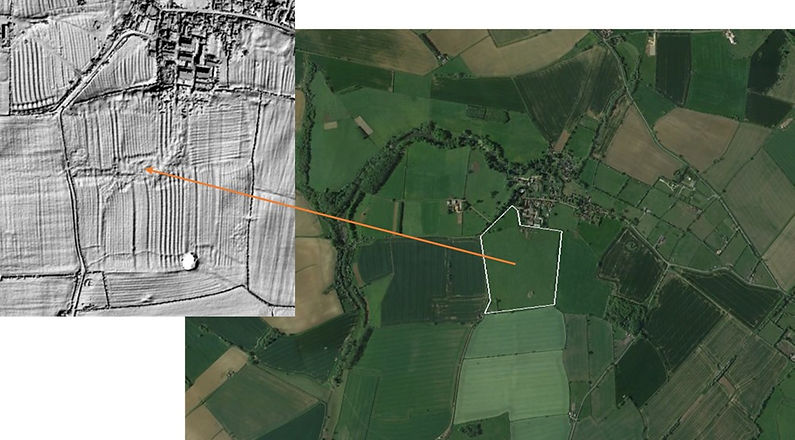
This LiDAR image of Clay Field shows the complex pattern of individual strips that would have been worked by several different tenant farmers prior to enclosure.
Glebe Terriers
The term Glebe Terrier is specific to the Church of England. The word ‘terrier’ derives from the Latin ‘terra’ meaning land or earth, and the Glebe Terriers are written surveys of land or other property held by the vicar, rector or perpetual curate for the support of himself and his church. The glebe land could be cultivated by the incumbent or by tenants to whom he leased it, and the terriers often include the names of the tenants and sometimes the holders of the adjoining lands. The documents that survive provide a comprehensive source for land tenure, agricultural practice, and topographical details covering the 16th, 17th and 18th centuries.
Throughout much of the 1600s the glebe lands in Goadby Marwood were located within two large open fields located on the south side of the village, close to The Rectory. One of these was Clay Field mentioned above, the other was Lamcoates, which covered a large area of land now associated with Hall Farm. In addition, the glebe included the small triangular paddock next to what is now the village hall. By 1674, the terriers show that both Lamcoates and Clay Field had been fully enclosed.
The glebe lands described in the terriers of the late 1600s onwards were located some distance away from The Rectory. These lands comprised three enclosed closes totalling around 30 acres, in addition to Glebe Leys, the small paddock by the village hall. The larger area became known as Glebe Farm and in later years was farmed as part of Bellemere Farm. The land (excluding the paddock by the village hall) and attendant buildings were sold in 1961 and all that remains of the farm buildings are a few derelict foundations.

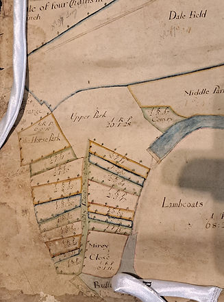
This detail from the Goadby estate map of 1715 shows the location of Lamcoates and Clay and clearly demonstrates that these fields were no longer being farmed in strips at the time of the survey.

Images from Google Earth showing the position of the now derelict Glebe Farm.
Bellemere Farm
Hall Farm
Examples of Glebe Terriers
1625 Glebe Terrier for Goadby Marwood
1708 Glebe Terrier for Goadby Marwood
1708 Glebe Terrier transcription
1781 Glebe Terrier for Goadby Marwood
1781 Glebe Terrier transcription
1825 Glebe Terrier for Goadby Marwood
1825 Glebe Terrier transcription